The Atlas Fire began the evening of October 8, 2017, and spread rapidly south. Our clients were evacuated from Monticello Park, Silverado Country Club, Hardiman/McKinley/Estee, Circle Oaks, Buchman, Wild Horse Valley Road, and Silverado Trail from Trancas to SR 128.
The fire blazed for 19 consecutive days. On October 27, 2017, it was declared fully contained. During that time, over 51,000 acres in Napa and Solano counties burned, 5000 structures were threatened, and more than 48o structures were destroyed. The Atlas Fire also incinerated portions of the Napa River, Suisun Creek and Putah Creek watersheds.
The impact of the Atlas Fire on homeowners was severe. 86% of the property damaged belonged to individuals and families. The most serious damage occurred in the following zip codes: 94503, 94581, 94534, 94558, and 94574.
Extinguishing the fire required 50 engines, 6 water tenders, 7 helicopters, 8 air tankers, 16 hand crews and the cooperation of over 400 workers from the following state and local agencies: CAL FIRE, Napa County OES, CHP, CDCR, Sonoma County OES and the Napa County Sheriff.
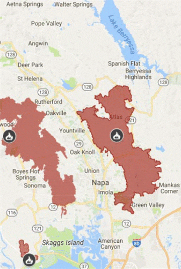
The perimeter of the Atlas Fire can be seen in the right-center of Figure 1 below.

Figure 1. Perimeter of Atlas Fire
Point of Origin. The origin points for the Atlas fire are off Atlas Peak Road in Napa.
Cause of Fire and PG&E. Shortly after the start of the Atlas Fire, PG&E informed the California Public Utilities Commission that there were incidents involving damage to its equipment on the very day of the fire, October 8, 2017.
PG&E reported incidents involving electrical wires and equipment at 3683 Atlas Peak Road and 4011 Atlas Peak Road. (PG&E Incident Report No. 171026-8596 and PG&E Incident Report No. 171020-8589). At 3683 Atlas Peak Road, PG&E reported that live electrical lines came into contact with an oak tree. At 4011 Atlas Peak Road, PG&E reported that a large tree limb fell into its equipment. CAL FIRE identified latitude/longitude coordinates for the location of the Atlas Fire a short distance south of the two PG&E incidents. (CAL FIRE Atlas Incident Information)
WERT Assessment. Since the Atlas Fire was extinguished, the surrounding area was evaluated by Watershed Emergency Response Team, a group of geologists, engineers, hydrologists and foresters, to evaluate the post-fire hazards to life and safety of persons in the area. http://www.fire.ca.gov/communications/downloads/Watershed_reports/20171115_AtlasFireWERT.pdf.
A fire the magnitude of Atlas can have profound effects on the environment, including erosion, landslides and floods. Debris flows are among the most hazardous consequences of rainfall on burned hillslopes. The WERT team commented that, “even small debris flows can strip vegetation, block drainage ways, damage structures and endanger human lives.” Accordingly, “As winter approaches, it is critical that people who live in and downstream from large wildfires implement emergency protection measures where appropriate, remain steadfast and alert of weather conditions, and be ready to evacuate if necessary during large storms.”
It is recommended that all homeowners review the WERT report and, if appropriate, speak to an engineer to determine any health-safety and environmental risks, including flooding, landslides and rock fall, that now exist because of the fire. Areas of particular risk include the following: Berryessa Knoxville Road, the Highway 128 corridor near Capell Valley), Capell Valley and Adams Flat, the Highway 121 Corridor near Monticello Road, Circle Oaks Drive Subdivision, Wooden Valley Road and Suisun Valley Road, Green Valley, Atlas Peak Road, Soda Creek and Soda Canyon Road, Silverado trail below Stags Leap, Milliken Creek and Silverado Country Club, Sarco Creek, Hagen Creek, Murphy Creek, Camille Creek (Skyline Park) and homes located in or near the FEMA 100 year floodplain.


